|
Arisaig is a Port Village 35 miles northwest
of Fort
William, 18 miles northwest of Glenfinnan, 8
miles south of Mallaig via the A830
road.
The Village is popular for its Land Sea and
Islands Museum, Restaurant, Hotel, Marine Cafe,
Sea Kayaking, Boat Trips, Walking Trails, and
the Silver Sands of Morar Beach is 5 miles
north.
For Images on Mobile swipe right
Click On Map for area
Attractions
Camping & Touring Parks in
area
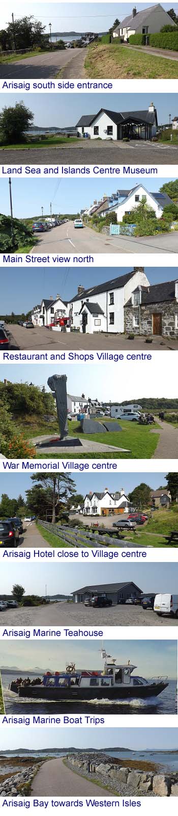
The image top is of the road down into
Arisaig from the south side. There is another
road down from the north side.
The Land Sea and
Island Centre is at the south side of the
Main Street, giving information on the Village
history with many images, films, books and
more.
The Village centre is about 200 yards from
the Land Sea and Island Centre with a
Restaurant and Shops.
Arisaig Sea Kayaking
offers trips from the Bay at the Village centre
for beginners and experienced Kayakers.
At the Village centre is the Czechoslovakian
Special Operations Executive Training Memorial.
This Memorial was erected in 2009 in honour of
Czech and Slovak soldiers that trained here
from 1941 to 1943 in Resistance, to operate
behind Enemy Lines during World War Two.
The Arisaig Hotel
is 100 yards north of the Village centre with a
Restaurant.
Arisaig Marine
Teahouse is across the road from the
Arisaig Hotel at the Marina, also with a Gift
Shop and great views over the Bay.
Arisaig Marine
operate a Ferry Service from April to October
to the Islands of Eigg, Muck and
Rum.
Arisaig Marine
also offer a range of Boat Trips and Charters
for Wildlife, Hidden Beaches, Snorkeling,
Paddle Boarding and more.
Walking Trails
- there are a number in the area from Coastal
to Mountains.
The Silver Sands of Morar Beach is 5 miles
north, next to the main road up to Mallaig.
Loch Morar is close to the Beach, also worth
a visit, deepest Loch in Scotland, also where
you can find the grave of David Sterling,
founder of the SAS, at Morar Village Church.
Large Images of
the Beach and Loch.
Arisaig History
700s - the Arisaig area was taken over by
Vikings at a time they had also taken control
of most Western Isles.
1000s - King Malcolm II of Scotland gained
control of the Arisaig area through an
agreement with the Vikings.
1100s - the Vikings took back control of the
Arisaig area with their descendants Clan
MacDonald, Lords of the Isles, holding the area
from the 1370s up to the 1800s.
1300s - Scottish Kings began installing
Clans loyal to the King to keep areas under
control, but the MacDonald's had regular
disputes with the Kings and still held onto
most of their lands.
The MacDonald's rented out many small
farms/croft's, the way most large land owners
did to fund their vast estates, castles and
mansions.
1720 - the earliest parts of the Arisaig
Hotel were built as an Inn for traders visiting
villages along the coast on boats, and for
cattle drovers, there were no roads at that
time, just narrow trails for walking and
horses.
1746 - there was a Naval Battle off Arisaig
between British and French ships, as the French
were landing Gold to help fund the Jacobite
war. The Gold was taken 20 miles inland to Loch
Arkaig to be hidden, where it is said to remain
to this day, with many people still looking for
it. The French ships escaped the Battle.
The MacDonald's of Arisaig, and many of the
people in the area, supported the Jacobite
Risings, trying to overthrow the King so a
Stuart King could be restored to the
throne.
Soon after the failed last Jacobite Rising
of 1746, with the last Battle at Culloden by Inverness in April,
Government Troops attacked people from the
Arisaig area, destroying their homes, forcing
many of them to emigrated to Canada, where they
founded Arisaig in Nova
Scotia in 1785.
1746 September - Prince Charlie Stuart
departed Scotland for the last time from a spot
5 miles southeast of Arisaig, now marked by the
Princes Cairn,
next to the main road with a layby for parking
at Loch nan Uamh, easy to miss, as I have done
4 times.
1820s - Ranald George Macdonald ran into
financial difficulties, leading to him selling
his Arisaig lands.
Lord Cranstoun took over the area, claimed
to be extremely cruel, leading to one of the
largest Clearances of people in the Highlands
to make way for large scale sheep farming and
deer hunting for the rich.
1850 - Francis Dukinfield Palmer Astley
purchased the Arisaig estate from Lord
Cranstoun.
1863 - Arisaig House was built for Francis
Dukinfield Palmer Astley 2 miles southeast of
Arisaig village.
1800s late, horse drawn Mail Coaches began
running between Fort William, Glenfinnan,
Arisaig and Mallaig, also taking
passengers.
Arisaig was one of the stops needed to
change or feed horses, and make repairs to the
Wheels of the Coaches, as the roads were
extremely rough. Villages with Coaching Inns
were about ever 10 miles.
1901 - the Fort William to Mallaig Railway
was completed with the vast Glenfinnan Viaduct,
also with a Station at Arisaig. This line was
built as Mallaig had become a top Sea Fishing
village.
1903 - cars and trucks started traveling
between Fort William, Glenfinnan, Arisaig and
Mallaig after Thomas Telford completed a new
single lane road made of layered crushed
stone.
1920s - Tar was put on top of the crushed
stone roads in rural areas of Scotland.
1935 - Arisaig House was severely damaged by
Fire, rebuilt soon after.
1940s - Arisaig House
was used for Special Operations Training during
World War Two, mainly to train Europeans to
work in Resistance against German forces
throughout Europe.
2009 - the main road was all double
lane.
2009 - a memorial to Czechoslovak soldiers
that trained as Special Operation Executives
from 1943 to 1945 was erected in Arisaig.
2021 - Arisaig House was put up for sale for
over £2 million, was sold the following
year to a multi-millionaire financier.
|