|
The 3,317ft, 1,011m Beinn Ime mountain is
situated on the north side of Loch Long at
Arrochar village, 2 miles west of
Tarbet at
Loch Lomond, 36 miles northwest of the city of
Glasgow.
Regular Buses run between Glasgow and Inveraray
stopping at Arrochar.
This is a fairly long Hike up a good Steady
Incline Path all the way, averaging about 6
hours out and back.
For Images on Mobile swipe right
Large Image
from Arrochar to the Car Park and
Mountains.
Click On Map for area
Attractions
Camping & Touring Parks in
area
Large Hiking OS
Map
The image top is of the Succoth Car Park at
Arrochar, next to the start of the Path to
Beinn Ime, there are two large Car Parks, best
to use the second one when driving round from
Arrochar.
This is a Pay and Display Park about
£1 per hour, you can Pay by Coins,
Card, or by Phone, some Phones may not get a
signal. Beinn Ime will take between 4 and 7
hours out and back, depending on how fit you
are and if you are in a hurry or not.
The Start of the Trail is right across the
Main Road at the Car Park, with a Bus Stop here
as well with regular Buses between Glasgow and
Inveraray passing through Arrochar.
The steady incline Winding Path goes up
through Woodland past a Bench, along a Forest
Road at the Bench for about 50 yards, then up
another steady incline Winding Trail through
Woodland.
Once you clear the Woodland, you will see
the Twin Peaks of the Cobbler up ahead, follow
this good steady incline Trail right out past
The Cobbler.
From between The Cobbler on your left and
Beinn Narnain on your right, you get a great
view up to Beinn Ime.
This low point between the 3 Mountains is
about 2,000ft /610m, so about 1,300ft / 396m
still to go up to Beinn Ime summit.
The Trail up to Beinn Ime is good in a Dry
Spell, may be a bit Soggy in the Rainy Season.
Large Image
Up.
The Trail goes up nice and Steady, with a
little Rocky Section close to the top.
Not sure if this is a man made Cairn on
Beinn Ime or natural.
You get great views all around from the top
as this is the highest Mountain in the Arrochar
/ Loch Lomond area.
From the Summit, you will see two other
Trails up, one from the West from Butterbridge,
and one from the East from Inveruglas, both
much tougher Trails, only taken on by Hikers
with Experience of No Trails and
Scrambling.
Butterbridge Large
Image
Inveruglas Large
Image
Following the same Trail back down between
The Cobbler and Beinn Narnain, you will see the
two good Trails up these Mountains. Large Image
Down.
It is about 1,000ft / 305m up to these
Mountain Summits if you have enough energy left
to do one, or even the two of these as well,
some really fit people do.
The Path back down to the Car Park seems
longer than going up, at least it is a steady
decline all the way.
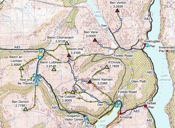
The Click on Map below shows the Tourist
Trails in Blue, Brown Rougher Trails, and Red a
Bit Dangerous.
Make sure and take an Ordnance Survey Map
and Compass on these Hikes, and know how to use
them, as in Cloud, these Mountains can be
deadly. In Winter, make sure you have Crampons
and an Ice Axe, and know how to use them.
Some people are now trying out OS Phone Apps
that can help.
|