Buachaille Etive Beag Hike
Buachaille Etive Beag is 7 miles east of
Glencoe
village, 85 miles northwest of Glasgow, with
two Munros, the 3,035ft, 925m Stob Coir as seen
in the top image right, and 3,143ft, 958m Stob
Dubh at the south end of the range, the peak in
the middle is not a Munro.
The top image right is from the A82 road
looking at the east side of Buachaille Etive
Beag, a top Mountain photo in Scotland. The
Mountain is too steep from this side for
hikers, is hiked from the west side where there
is a car park about 1 mile further down the
road.
The Glasgow to Fort
William & Skye bus passes here but the
closest stops are at the Glencoe Ski Centre 5
and a half miles east, or the Glencoe Visitor
Centre 5 and a half miles west.
For Images on Mobile swipe right
Click On Map for area Attractions
Camping & Touring Parks in
area
Just before you pass the Mountain, you will
see a car park with a sign for the path down
the east side named Lairig Gartain. This path
leads 5 miles to Glen Etive, a good path for
photos.
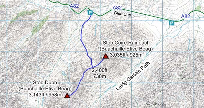
The car park for the hike is right next to
the main road on the west side of the Mountain,
as seen right, at about 600ft /200m above sea
level.
A good path leaves from the car park running
up between the first two peaks to about 2,400ft
/ 730m, this is the trail you come back down as
well, only safe way up and down.
Once up on the ridge between the first two
peaks where there is a large cairn, that is the
toughest section completed, with most people
then heading south to the south peak name Stob
Dubh as it is the highest and most scenic with
a bit of a rocky ridge up to the summit, also
it is a nice steady incline trail with good
views south down Glen Etive.
The middle peak is not a Munro, must be
classed as a part of Stob Dubh.
On the same route back, some people visit
the north peak named Stob Coir that is steeper
with loose rock much of the way, then go back
down the same path to the car park, some go to
one summit one day, then return for the other
summit another day.
The best views from Stob Coir are from about
30 yards west of the Summit Cairn looking west
down Glen Coe to the large Glen Coe Viewpoint,
also straight down into the Car Park.
I estimate it is about 3,300ft / 1,006m of
hiking visiting the 3 peaks including the ups
between the mountains and taking away the 600ft
that the car park is above sea level, so will
average 5 and a half hours hiking, add time on
if you like a few breaks.
These are regarded as the easiest and safest
of the Glen Coe Mountains, so probably the
first ones you should hike when in the
area.
Make sure and take an Ordnance Survey Map
and Compass on these hikes, and know how to use
them, as in cloud, these mountains can be
deadly. In Winter, make sure you have Crampons
and an Ice Axe, and know how to use them.
Large OS Map .
28 Large
Images
All Mountain
Tours
|
