|
Hill walking in Scotland is a popular leisure
activity with locals and visitors from around the
world. There are 283 Mountains above 3,000 feet known
as Munros, with now over 4,000 people claiming they
have climbed them all.
There are 221 between 2,500 & 3,000ft known as
Corbetts, and about 1,000 about 2,000ft. Most have
fairly safe walks to the summit and can be completed
to the top and back between 3 and 8 hours.
Altitude sickness begins at around 8,000 feet, so
all are well below that with the highest Ben Nevis at
4,408 feet. The difference between a Mountain and a
Hill is a Mountain has steeper sides and a
distinctive peak.
The list below contains places that are extremely
popular, scenic and normally have facilities close
by.
A full list of the highest Mountains in the UK can
be found at the bottom of this page.
|
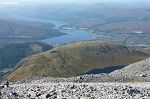
Ben Nevis
Highlands 2 miles southeast of Fort William. Ben
Nevis is the highest Mountain in the British Isles,
attracting about 225,000 visitors a year, with most
Walkers using the Mountain Trail from the Glen Nevis
car park and Visitor Centre to the summit at 4,408 ft
above sea level. Novice Walkers following the Tourist
Path take about 3 to 5 hours to reach the summit. For
Climbers and Mountaineers, the main attraction is the
2,300 ft high cliffs of the north face.
ben-nevis.com . Wiki Page . Map . Reviews . Area info &
Hotels . Large Image
walkhighlands.co.uk/bennevis
|

Cairngorm Mountain
10 miles southeast of Aviemore. Cairngorm is a vast
Mountain Range in the Gairngorms National Park by the
town of Aviemore in the Scottish Highlands. At 4,084
ft, Cairngorm mountain is the sixth highest in the
United Kingdom. This is a popular hiking area with a
number of high Mountains, including the second
highest mountain in Scotland, Ben Macdui at 4,292ft,
guides are available from the website. Scotland's top
Ski Resort was developed here from 1960, and the
Cairngorm Mountain Railway was opened in 2001. The
Top Station has a Visitor Centre and Restaurant with
some of the best views in Scotland. The top Ptarmigan
Station is at about 3,599 ft and car park at 2,000
ft.
cairngormmountain.co.uk .
Wiki Page . RS Page .
Large Images
Aviemore Area
info & Hotels . Map . Reviews . RS Hiking
Page
|

Ben Lomond
36 miles northwest of Glasgow. Ben Lomond is one of
the most climbed Mountains in Scotland as it is the
most southerly of the Munros, Mountains over 3,000
feet, also, it is situated close to Glasgow,
Scotlands largest city. This is many walkers first
Munro. The Mountain, at 3,196 feet, is in the scenic
Loch
Lomond National & Trossachs Park. The
Roardennan Hotel and Lodges
are situated next to the start of the Mountain Trail.
You can watch the Hikers from the bar if you have
binoculars.
Photo
Tours . Map. Wiki Page . Large Images
Area info &
Accomodation
|

Goat Fell
Isle of Arran southwest Scotland. Goat Fell is the
highest Mountain on the Isle of Arran at 2,866 feet
or 874 metres. The Isle of Arran is probably the most
scenic Island in Scotland. The main Trail to the
Mountain starts at Cladach about 2 miles north of the
main town and ferry port of Brodick. Goat Fell has
spectacular views over the Island and Firth of Clyde
to Scotland. There are many more Mountains for hard
hikes with knife edge ridges, and many less enduring
scenic hills for walking all around the Island. A
relatively flat but incredible walk is from the
Corrie Golf
Course 5 miles north of Brodick, that leads
between the Mountains. The Golf Course has a car park
and Tea Room. The main Tourist Trail up Goat Fell
normally takes between 4 & 5- hours to the top
and back.
Photo Tour . Wiki Page . Area Info &
Hotels . Map. Large Images
|

Ailsa Craig
An Island in southwest Scotland 10 miles off the
coast from the town of Girvan. Ailsa Craig is an
Island Bird Sanctuary that can be visited by Hill
Walkers, 1,110 feet high. Boat trips from the Town of
Girvan allows about 3 hours on the Island for a walk
to the top for some dramatic views of Scotland,
Ireland, Isle of Arran and Mull of Kintyre, as well
as the Birds and Seals.
AS Page/Ailsa Craig .
AS Page/Girvan .
Hiking Photos .
Map .
|
England & Wales
There are 15 Mountains in Wales over 3,000 feet
and 6 in England.
Below is a list of some of the most scenic hill
walking in England and Wales.
|

Mount Snowdon
In the north of Wales 73 miles southwest of
Liverpool. Snowdon is the highest Mountain in Wales,
said to be the most climbed Mountain in Britain. It
is situated in Snowdonia National Park in Gwynedd.
The summit is 3,560 ft above sea level. The Snowdon
Mountain Railway now runs to the top for anyone not
fit enough to walk to the top. A Restaurant and Shop
are at the Top Station, just below the summit with
incredible views. The easiest Walking Routes take
about 6 hours to the top and back.
visitsnowdonia.info .
Wiki Page . Map . Reviews . Large Image
mountainwalk.co.uk/snowdon
|
Grasmere
In the centre of the Lake District, Cumbria England.
Grasmere is a small Village in the Lake District that
attracts vast numbers of Hill Walkers. The hills,
from 1,000ft to 2,800ft, have great views over the
lakes and there is also a flat walk around the lake.
The Village has Cafes and about 9 Hotels, most of
which provide meals and drinks for residents and non
residents.
Grasmere Page with Hiking
Tours . Map . Large Images
|

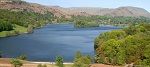
Keswick
In the Lake
District, Cumbria England. Keswick is a small Town in
the Lake District with hills that have some
exceptional views over the scenic town and Derwent
Water. The highest Hills are on the north side of the
town such as Skiddaw, the fourth largest
in england at 3,054 feet. The more scenic hills are
on the west side of the lake, as seen in the image
right. The town has a number of hotels, restaurants
and cafe's that cater for the many hill walkers in
the area. There are also a good variety of hill
walking shops in the town.
Keswick Page with Hiking
Tours . Map . Large Images
|

Scafell Pike
The Lake District, Cumbria England. Scafell Pike is
the highest Mountain in England at 978 metres or
3,209 ft. The second largest mountain in England, Sca
Fell, is situated on the same ridge. These Mountains
are in a remote location, about 12 miles south of
Kestwick. Or the more remote south side hike starts
from WasdaleHead. The easy walking route takes about
5 hours to the top and back. The Wasdale Head Inn is where the south side
trail begins, with mountains all around.
Wiki Page . North Route Photo
Tour . South Route Photo
Tour .
Google Map. Large Images
|

Glenriddng
East side of the Lake District 14 miles southwest of
Penrith at the M6. Glenridding is a small scenic
Village on the south side of the lake name Ullswater.
The Hills overlooking the Village and lake are
extremely popular with Hill Walkers with a range of
Walks to suit everyone. For the more adventurous hill
climbers, there is the mountain named Helvellyn, 3rd highest in
England. This walk is about 5 miles out from
Glenridding with the summit being 3,250 feet or 985
metres, and one route takes you round the knife edge
ridge, named Striding Edge. Glenridding has two
Hotels and a Travelers Rest that cater for Hill
Walkers.
Glenridding Page with
Photo Tours . Map . Large Images
|

Roseberry Topping
Northeast England on the North York Moors. Roseberry
Topping is the second largest hill on the North York
Moors at 1,050 feet or 320 metres. It is now managed
by the National Trust attracting many Hill Walkers
with a large roadside car park. Roseberry Topping is
about 1 mile outside the scenic village of Great Ayton that has two
Inns for Meals and Drinks. This is a Hill not to be
missed if you are in the area.
National Trust Page .
Wiki Page . Map . Large Image
|
|
