|
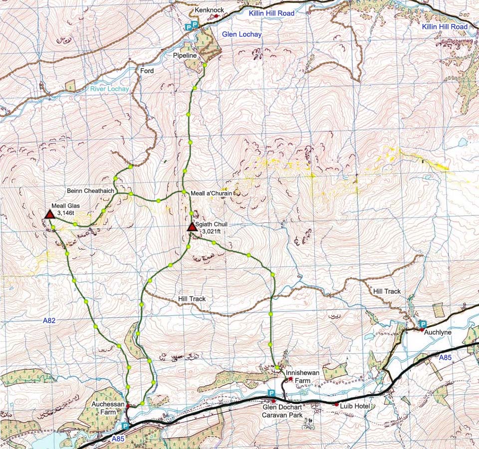
The map below shows the five routes onto
Meall Glas and Sgiath Chuil. The main route
from the south is from Auchessan Farm. The
car parking for that route is on the
roadside next to the entrance to the farm
road, 4 miles east of Crianlarich. The
roadside parking is wide, flat grass, so
plenty of room for many cars. The Auchessan
road is easy missed as it is narrow and
goes through trees. There are some trails
on this route, although easy to lose, and
can be soggy in the lower sections.
Meall Glas and Sgiath Chuil Photo Tour
from Auchessan Farm.
Auchlyne is a Mansion House, farm and a
few cottages with a single lane road
leading to it with many passing places. A
hill track runs from Auchlyne to Sgiath
Chuil, an ideal route for that mountain to
avoid the soggy lower sections in wet
weather. There are a few parking places at
Auchlyne by the walled garden. The hill
track leads up beside a cottage, by a small
bridge and cattle grid. Auchlyne Track
Image. Auchlyne
Map drag the Wee Man onto the road for
images.
Auchlyne Route
Photo Tour .
The main route from the north is take
the single lane hill road from Killin to
just past Kenknock Farm where there is
loads of parking by the large pipeline,
about 8 miles west of Killin. There is an
old hill road that crosses a ford, so
waterproof boot covers or wading will be
needed, then runs all the way up to the
north side of Meall Glas and its sub peak
Beinn Cheathaich. Another route is over a
bridge then up past the pipeline towards
Sgiath Chuil and its sub peak Meall
a'Churain. Road Map
drag the Wee Man onto the road for
images.
Kenknock Route
Photo Tour.
Make sure and take an Ordnance Survey
Map and Compass on these hikes, and know
how to use them, as in cloud, these
mountains can be deadly. In Winter, make
sure you have Crampons and an Ice Axe, and
know how to use them.
Crianlarich
Road Map
Hill Walking OS
Map
Crianlarich Photo Tour
|
