Highlands Scotland Click On Map

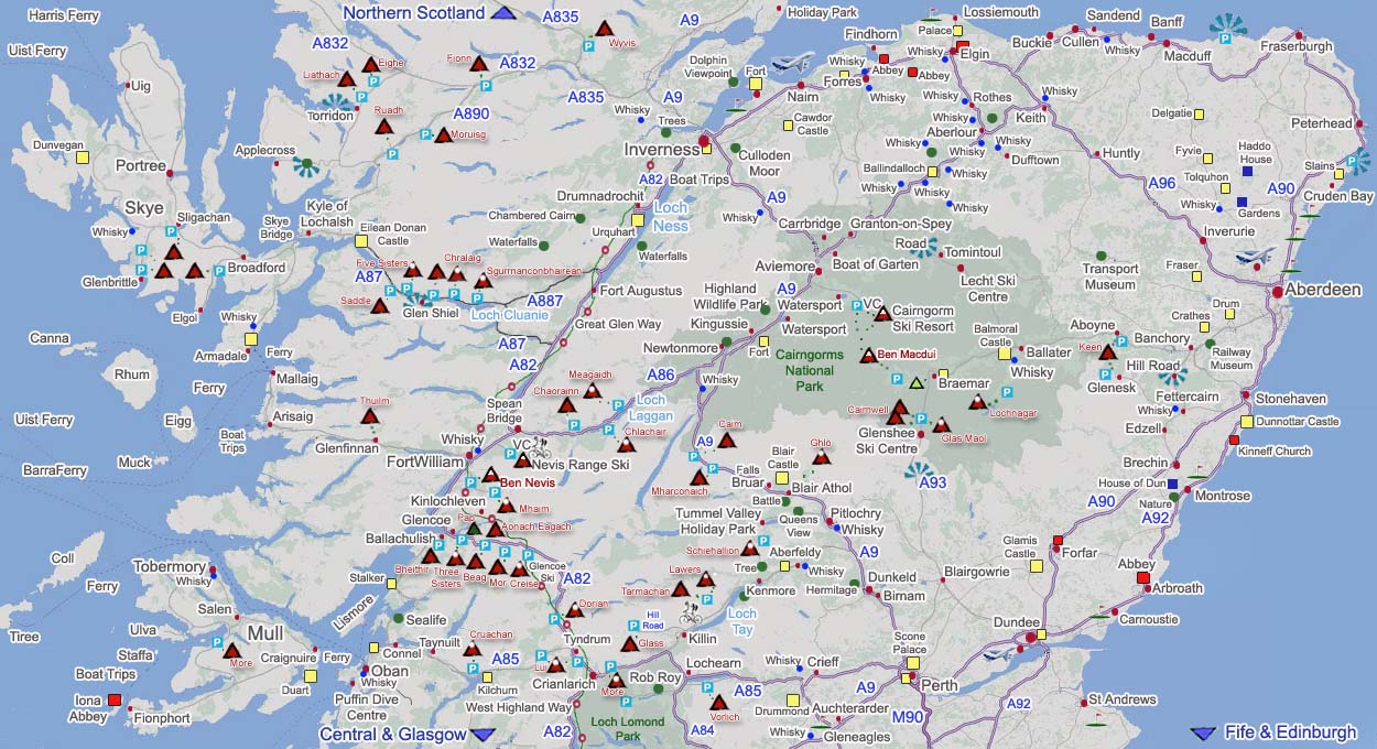
An Interactive Click On Map of the Highlands in Scotland showing mountains, hills, activities, hotels, towns and top attractions.

Click on the towns for information on that town and accommodation, green dots for attractions, VC for visitor centres, triangles for hills/mountains.

The golf flags on this map only shows the top golf clubs. Most towns have at least one good golf course, for all golf courses visit the Golf Section.

The red and white dots show the West Highland Way that runs from Glasgow to Fort William, and the Great Glen Way that runs from Fort William to Inverness.

There are over 283 Mountains in Scotland between 3,000ft and 4409ft. This Map shows the main mountain ranges that have car parks next to main roads. These car parks have some of the best views in Scotland, photo shots. For all Mountains, see
Scotland Mountains
.

There are many more attractions in & around the towns/cities. These pages have links to websites and maps with postcodes.

Aviemore . Aberdeen . Dundee

Fort William . Inverness . Perth

Stirling

Holiday Lodges . Holiday Parks

Whisky Distillery Visits

Touring & Camping Parks . RS Home

Highlands Map Grannies Heilan Hame website Inverness Nairn page Elgin page Buckie page Macduff page Fraserburgh page Peterhead page Aberdeen web Stonehaven Page Dunnottar Castle web Montrose page Arbroath page House of Dun Carnoustie page Carnoustie Golf Club website St Andrews websites St Andrews Area Golf Clubs Dundee page Fife & Edinburgh Area click on map Gleneagles Auchterarder web page Perth websites Scone Palace Crieff web Glamis Castle web Drummond Castle Tullibardine Distillery visits Tummel Valley Holiday Park Forfar page Brechin websites Blairgowrie web Dunkeld web Lochearnhead page Loch Lomond Area click on map West Highland Way web page Great Glen Way web page Crianlarich page Tyndrum Killin web Aberfeldy web Pitlochry web Blair Athol web Blair Rob Roy Grave web page Ben Vorlich page 3231ft Ben More page 3851ft Ben Lui page 3707ft Meall Glass page 3146ft Glenshee Glencoe Mountain Braemar web Aberdeen Airport page Balmoral Castle web Lecht Ski Centre Ballater page Aboyne page Grantown Highland Wildlife Killin Biking website Aviemore Inverurie page Huntly page Keith page Dufftown page Aberlour page Ballindalloch Castle website Culloden Cawdor Castle visits website Drumnatrochit web Urquhart Augustus Cairngorm Aberlour Distillery Glenfiddich Distillery Glen Grant Distillery Glen Moray Distillery Strathisla Distillery Nevis Range page Spean Bridgepage Fort William Glen Coe Oban Dunstaffnage Kilchurn Castle Stalker Isle of Lismore website Scottish Sea Life Sanctuary website Connel Page Puffin Dive Centre website Oban to Craignuire Ferry website Craignuire page Fionnphort page Salen page Tobermory page Mull Iona page Staffa websites Staffa Boat Trips websites Ulva page Ben More Isle of Muck websites Isle of Eigg websites Rhum websites Canna websites Malaig to Rhum Muck Eigg Canna Oban to Coll and Tiree Ferry Oban to Barra ferry website Oban to South Usit ferry website Mallaig to Sky ferry website Isle of Skye Isle of Coll website Isle of Tiree website Arisaig Boat Trips website Arisaig page Mallaig page Armadale page Kyle Eilean Donan Portree page Uig page Uig to Harris ferry website Uig to North Uist ferry website Northern Scotland Map Skye Bridge page Castle Stuart Golf Club Royal Aberdeen Golf Club Trump International Golf Links Grampian Transport Museum Banchory Deeside Railway Crathes Castle page Lossiemouth web page Moray Golf Club Montrose Golf Club Ben Cruachan Beinn Dorain Buachaille Etive Mor Bidean nam Bian Beinn a'Bheithir Aonach Eagach Central Scotland click on map Ben Nevis Sgurr a'Mhaim range 3605ft Beinn a'Chlachair range 3566ft Beinn a'Chaorainn range 3366ft Creag Meagaidh range 3707ft Sgurr nan Conbhairean range 3641ft Sgurr a'Bhealaich Dheirg range 3405ft Sgurr Fhuaran range 3503ft The Saddle range 3313ft  Sgurr nan Gillean range 3162ft Sgurr Alasdair range 3257ft Ben Wyvis range 3431ft Fionn Bheinn range 3061ft Sgorr Ruadh range 3156ft Moruisg range 3044ft Beinn Eighe range 3257ft Liathach range 3461ft Ben Macdui range 4294ft Ben Lawers Meall nan Tarmachan range 3425 Morrone hike 2818ft Beinn a'Ghlo range 3678ft Carn na Caim range 3070ft A'Mharconaich range 3198ft Glas Maol range 3503ft 3 Loch Ness Boat Trip companies Ballachulish websites Inverness Airport page Dundee Airport website Dewars Distillery visits A' Chralaig range 3675ft Bla Bheinn range 3045ft Torridon Page Chanonry Point Fort George Reelig Glen Glen Ord Distillery Tomatin Distillery Corrimony Chambered Cairn Plodda Falls Falls of Foyers Drum Castle Castle Fraser Pitmedden Tolquhon Glen Garioch Distillery Haddo House Fyvie Castle Delgatie Castle Knockando Glenfinnan page Buachaille Etive Beag Taynuilt page Arbroath Abbey Page Montrose Basin Talisker Page Torabhaig page Cooperage Royal Lochnagar Cairnwell A93 Road Schiehallion Glenturret Castle Menzies Web Fortingall Yew Queens View Hermitage Blair Athol Birnam Page Killiecrankie Bruar Newtonmore Kingussie Town Ruthven Glen Shiel Applecross Page Sligachan Page Glenbrittle Page Kinneff Church Edzell Page Cairn O' Mount Glenesk Page Fettercairn Page Dunvegan Duart Cruden Bay page Cruden Bay Banff page Sandend page Cullen page Forres page Spynie Palace page Pennan Broadford page Boat of Garten page Dalwhinnie Loch Morlich Loch Insh Carrbridge Page Cragganmore Ballindalloch Glenfarclas Macallan Distillery Benromach Distillery Dallas Dhu Distillery Cardhu Distillery Glenlivet Distillery Armadale Castle Page Rothes page Findhorn Page Kinloss Abbey page Tomintoul page Road Ben Nevis Distillery Page Pluscarden Glenglassaugh Slains Castle Bullers of Buchan Mount Keen Lochnagar Kenmore page Pap of Glencoe Kinlochleven page Sgurr Thuilm Elgol

These mountains should only be climbed with an Ordinance Survey Map and good knowledge of using a Compass. Try to memorize the trail up, and take the direction of the trail with a compass, so if clouds roll over, you can find your way back down. Some of these mountains lead out into vast areas of wilderness.

Snow or Ice Conditions should only be attempted after ice training, and with the correct equipment.

rect" coords="1184,309,1222,327

Layers of clothing should also be taken as it can get bitterly cold at the top, even in summer, i.e. fleece, gloves, hat and weatherproofs. Drinks and snacks should also be taken. Mobile phones may work from some Mountains, but not all.