Beinn Bhuidhe Hike

RS Home RS Hiking

Where: Beinn Bhuidhe by Loch Fyne in central Scotland
Height: 3,110ft, 948m

Beinn Bhuidhe is situated on the north side of Loch Fyne, 8 miles northeast of Inveraray, 49 miles northwest of the city of Glasgow.

The image below is from the bridge leading to the hiking car park at the north end of Loch Fyne, at the entrance to the Auchadunan Brewery road.

Beinn Bhuidhe is 4 to 5 miles out from the hiking car park here so only really hiked by Munro Baggers, left of the mountain out there with snow on it. Some hikers use bikes to go out most of the way to a place to tie up bikes.

There are two roads out, the one to the right of the bridge is good tar much of the way past the brewery, the most popular route. The one to the left from here is a dirt road through a Gravel Pit, or Quarry.

Glasgow to Loch Fyne Road Map

Beinn Bhuidhe Route image

The image below is of the Beinn Bhuidhe hiking car park built by the estate. Note the height bar at the entrance, about 7 or 8 feet high? The car park is next to the bridge, on the west side of the River Fyne.

If you are biking or hiking out to the waterfalls route, go back over the bridge and down past the brewery, as it is a much better road.

Going through the quarry and up the Old Hill Road, take the road straight out the car park, down the west side of the river.

Beinn Bhuidhe Car Park image

The image below is from the route to Beinn Bhuidhe as it goes round to the power station and quarry. The white line shows the Old Hill Road that leads up through the trees into the mountains, to about 900ft. A local stated this is the most direct route, and the climb is spread over a longer distance.

Beinn Bhuidhe Quarry Route image

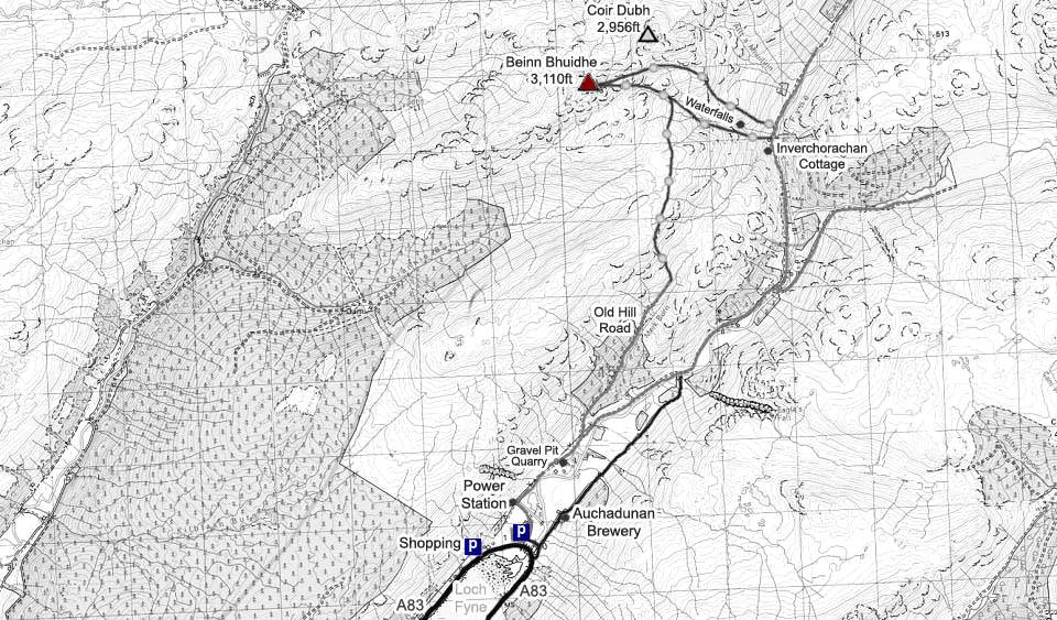
The Map below shows the routes to Beinn Bhuidhe. The waterfalls route is the most popular as it is steep and scenic with a well worn path to follow, and a narrow ledge to cross. Most hikers taking that route descend the north side of the falls, as it is not as steep, and a lot faster way down. The 2,956ft Coir Dubh can also be bagged on the route back down, and the 2,634ft Ceann Garbh is the next mountain to the north. The waterfalls route can be dangerous in ice and snow.

The Old Hill Road route goes past the Power Station, through the Quarry, then up through the trees to about 900ft. The reports for that route do not state what the hiking is like from the end of the Old Hill Road to the top, about another 2,000ft from there, no path, so may be rough going in places.

Make sure and take an Ordnance Survey Map and Compass on these hikes, and know how to use them, as in cloud, these mountains can be deadly. In Winter, make sure you have Crampons and an Ice Axe, and know how to use them.

Hill Walking OS Map

Beinn Bhuidhe Photo Tour to the Top Waterfalls Route

Beinn Bhuidhe Photo Tour to the Top Old Hill Road Route

Inveraray Accommodation & Photos

Beinn Bhuidhe Map image