|
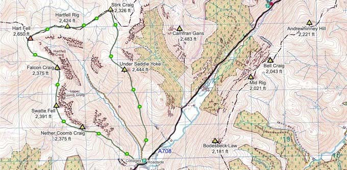
The 2,650ft, 808m Hart Fell is 6 miles east
of Moffat
in South Scotland on the A708 Hill Road between
Moffat and Selkirk, 66 miles southeast of
Glasgow.
For Images on Mobile swipe right
Click On Map for area
Attractions
Camping &
Touring Parks in area
The Image top is from Moffat centre looking
down to the corner where the A708 Road to
Selkirk and Hart Fell starts.
Wigwam Holidays is 5
miles east.
The second image is from Roundstonefoot Hall
looking at the Hart Fell hills/mountains. The
Pointy Mountain is Under Saddle Yoke. You can
park here and hike up to the left straight to
Hart Fell.
The third image is of the parking at
Capplegill Cottages with the start of the Trail
through the Gate and straight up towards Under
Saddle Yoke at 2,444ft.
The first section is real steep, then a
level walk before another steep section to the
summit of Under Saddle Yoke. This is the best
looking mountain on this horseshoe, so a good
way to go round.
There is a narrow path across between Under
Saddle Yoke and its Sister Peak, an area with
great views and a long drop down, but fairly
safe.
From the Sister Peak, you can go over to
Stirk Craig 2,326ft, or just go over to the
right and up to Hart Fell. You cannot go
straight over as there is a deep Gorge.
The low part up to Hart Fell is fairly
soggy, so waterproof boots and gaiters are
advised.
The top of Hart Fell is like a huge hill,
not much to see, but the Trail back down the
West Ridge has a number of View Points over
Cliffs.
The Trail down to Swatte Fell at 2,391ft has
a couple of fairly steep up and down sections,
then rounds Cliffs for some great views.
Large Image up
to Hart Fell from Swatte Fell.
There is a View Point at Swatte Fell out
over the Cliffs that is a bit of a test on a
day with no wind, not sure if I would venture
out on a windy day. Large
Image.
From Swatte Fell follow a trail down towards
a Gate and Cairn. You need to use the gate as
there is an Electric Fence.
From the Lower Cairn, go over to the right
then follow the real steep Trail down next to
the Gorge.
Once down, go round to the Gate onto the
Main Road, then it is just a short walk back to
the Car Park.
This seems to be a popular Hike in both
directions.
The Hike round this Horseshoe averages about
5 hours.
|
