|
The 2,900ft, 884m The Cobbler / Ben Arthur
mountain is 44 miles northwest of Glasgow, at
Arrochar, 2 miles west of Tarbet at Loch
Lomond, on the A83 Road up to Inveraray.
Regular Buses run between Glasgow and Inveraray
stopping at the Arrochar Hiking Car Park.
This is not a Munro as is just under
3,000ft, but is one of the most popular
Mountains in Scotland due to its looks.
There is a safe Tourist Trail all the way.
The Tougher Trail with a bit of Scrambling is
fairly safe in Summer when no Ice. Spikes and
Ice Axe may be needed from October to mid
April.
For Images on Mobile swipe right
Click On Map for area
Attractions
Camping & Touring Parks in
area
Large OS
Map
The best place to get a good view of the
Mountains is from Arrochar looking across Loch
Long. Large Image
from Arrochar with paths.
The top image is of one of two large Car
Parks around below the Mountains, right where
the Trail starts. These are Pay and Display Car
Parks, about £1 per hour. The
Cobbler will average 5 hours up and back,
longer if you want a few long breaks. There is
a Coin Machine and Credit Card Machine, or you
can pay by Phone, most Phones get a reception
here.
The start of the Trail is right across from
the second Car Park and Bus Stop.
The Trail has a good sign at the start, with
the first section Zig Zagging up through the
Woodland, allowing a steady hike much of the
way.
You pass a Summer Seat where the Path
crosses a Forest Road, walk along the Forest
Road about 100 yards west past a
Telecommunications Tower then up another
Woodland Path.
Once out onto the Hillside, there is a good
steady Trail straight up to The Cobbler.
You pass a small Dam on the Trail, some
people cross over at the Dam and go up the West
Ridge, normally people that have been up a few
times and looking for a different route.
The Main Trail takes you to the bottom of
The Cobbler east side, where you get the choice
of straight up the Scramble Route, or go round
and up the safer Hiking Trail. Both Trails are
real steep. The Main Trail is about 1,900ft
here, so about 1,000ft to go to the top. Tough
Route Large
Image.
I went up the Tough Route towards a Large
Cairn at the Low Point. This is fairly easy
with a Faint Trail most of the way, just a few
spots you have to pick your way up through
Boulders. There is a couple of places you have
to Climb up about 6 feet, but no places where
you are close to high drops, ideal for your
first Scramble.
Up to the east side Summit also has two
routes, round and up the Safe Hiking Trail, or
up the Scramble Trail shown right. The Steep
Trail has a bit of danger close to the top as
you have to cross a large sloping rock right
above the Cliffs, was tricky dry, be real
dangerous wet. Large Image
On a clear day this is a fairly safe
Mountain, best avoided in Thick Cloud though as
not a lot of room at the top and Cliffs are
much of the way around.
Crossing over to the West Summit is easy,
back down the Tourist Trail then across and
up.
There is a Rock Stack on the West Side
popular with Climbers, Real Dangerous if you do
not have Climbing Experience. Large Image
Most people go back down the safe Tourist
Trail, that goes down and round the north side.
This is a Man Made Path much of the way, real
steep in places. Most people go up this
way.
Once at the bottom, turn right and follow
the Main Trail back down to Arrochar. Large Image of
the Tourist Route Up.
Some people also hike Beinn Ime and Beinn
Narnain on the same day, people that are
exceptionally fit.
You get some great views of Arrochar on the
Main Trail back down, especially at the Summer
Seat.
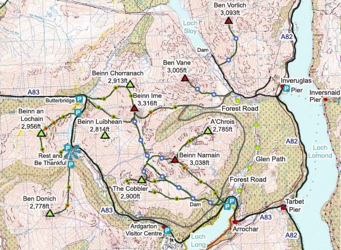
The Click on Map below shows the Tourist
Trails in Blue, Brown Rougher Trails, and Red a
Bit Dangerous.
Make sure and take an Ordnance Survey Map
and Compass on these Hikes, and know how to use
them, as in Cloud, these Mountains can be
deadly. In Winter, make sure you have Crampons
and an Ice Axe, and know how to use them.
Some people are now trying out OS Phone Apps
that can help.
|