|
The 2,696ft, 821m White Coomb is 10 miles
east of Moffat in South Scotland on the A708
Hill Road between Moffat and Selkirk, 70 miles
southeast of Glasgow. This area is better known
for the Grey Mares Tail Waterfalls, that can be
viewed from the Car Park area.
For Images on Mobile swipe right
Click On Map for area
Attractions
Camping &
Touring Parks in area
The Image top is from the centre of Moffat
looking down to the corner where the A708 Road
to Selkirk and White Coomb starts.
Wigwam Holidays is 5
miles east.
The second image is 10 miles east of Moffat
approaching the Car Park, you often get Fighter
Aircraft coming up through this Valley at a few
hundred feet. This is a narrow road in places,
30 to 40 mph most of the way.
There is a large Car Park and a smaller Park
close by. Cross the Hiking Bridge to the
Waterfalls Viewing Area with information.
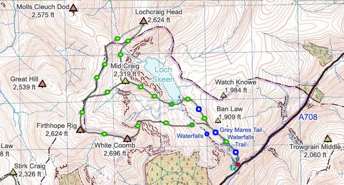
The Trail starts at the Viewing Area, fairly
steep up past the Waterfalls to about
1,600ft.
As soon as you pass the top Waterfall, you
will see the remains of a Stone Dyke across the
Burn, that Dyke leads up through Cliffs to the
2,696ft White Coomb. You have to look for
Stepping Stones to cross the Burn if going up
that way.
From the Top Waterfall, it is a fairly long
level walk out to Loch Skeen at 1,673ft.
As soon as you reach the Loch, you will see
the Stepping Stones to cross over to Mid Craig,
the best dry Trail up, with great views.
You can go round to the right of the Loch
and up to Lochcraig Head that way, but that
Trail has a few wet sections.
The Trail up to the 2,319ft Mid Craig is
steep and dry, apart from a short soggy section
at the bottom.
From the top of Mid Craig, start round to
the right following a faint trail up to
Lochcraig Head at 2,624ft.
Going up this West Ridge of Lochcraig Head
gives great views down over Loch Skeen.
From the top of Lochcraig Head, look west
over Mid Craig and you can see the 2,650ft
White Coomb.
The Trail Round to White Coomb sets off over
to the right of the Cairn to a Fence, that
Fence and Dyke lead all the way round to White
Coomb, and back down to the Main Trail.
There is only one little steep section on
the Trail round, then it is a long steady
walk.
The Cairn on White Coomb is about 100 yards
right of the Dyke, remember and come back to
the Dyke to get the Trail down through the
Cliffs, only safe way down.
The Trail down from White Coomb following
the Dyke is a bit rough and soggy in places,
and steep down through the Cliffs, but no
scrambling required.
Once back at the Main Trail, you have to
look for the best Stepping Stones to cross the
Burn, I had to go about 100 yards left to cross
safely.
Back on the Main Trail, it is back down the
steep section past the Waterfalls, then back to
Moffat for lunch.
This Route averages about 5 hours, with
Waterproof Boots and Gaiters recommended most
of the year. Hiking Poles are also handy for
crossing the Stepping Stones and for some of
the Steep Sections.
|
